
Mapping Sewage Dispersion Using Dye Fluorescence
Marine scientists from the Cawthron Institute, New Zealand, are studying the dispersion and dilution of sewage in coastal waters. They release a stable, non-toxic, dye immediately downstream of the effluent outfall pump, then monitor the fluorescence and position of the dye. To acquire this data they are using Windmill data acquisition software.
While dye is being injected into the effluent, the scientists determine the dye concentration in the water around the outfall. They do this by boat - continuously taking fluorescence readings using a Turner Designs Model 10 field fluorometer connected to a Notebook PC. To record the location of the measurements, they also attach a GPS receiver. The fluorescence, temperature and position readings are captured by Windmill software running on the Notebook and reading data from the PC's RS232 (COM) port.
Windmill immediately passes the acquired data to Arcview GIS software, which displays the readings directly on a rectified aerial photo or chart. This way the scientists generate maps of all the captured data in real-time. For example, fluorometry data is displayed on-the-fly as graduated dots depending on the signal returned (as in the diagram below). "It works a treat" according to Paul Barter, a marine scientist working on the project.
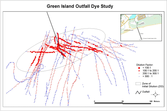
Reduced Map of Dilution within the Effluent Plume
For an enlargement click over the map.
As a backup, Windmill also logs all the readings to a single text file, time stamping each data set. If the real-time mapping should fail, therefore, the maps can be later created from the saved data.
Dye Study Methods
To make the readings from the fluorometer suitable for input to the PC, a Campbell Scientific CR-10 datalogger is used to convert them into RS232 serial data and pass them to the COM port of the laptop. Windmill uses dynamic data exchange (DDE) to transfer these, and the GPS co-ordinates, to the Geographic Information System (GIS) software package - Arcview - in real-time.

Dye Study Setup
Data is collected by running a series of transects through the effluent plume both perpendicular and along the effluent path. The fluorometer is set up for flow-through measurements, which entail the instrument being attached to one end of a hose, and a 12 volt submersible bilge pump attached to the other around 0.5 m below the surface. The scientists maintain a consistent boat speed by running at idle for the duration of the study. The sampling interval varies depending on location, and ranges from one reading per second to one reading every five seconds.
Other Applications
The scientists have used the system on other outfalls, and for other applications. For example, using the same setup but with the fluorometer calibrated to a different wavelength, they've measured the in-situ depletion of chlorophyll-a in the water column downstream of mussel farms.
About Windmill Software Ltd
Established 1990, Windmill Software Ltd specialise in data acquisition and control software for Windows. An updated version of the software used in this application is available from Windmill's data acquisition catalogue.
About the Cawthron Institute
The Cawthron Institute is a private, independent, not-for-profit research centre which has been operating in New Zealand for 83 years. Their purpose is to benefit the region through science and technology, especially the aquaculture of shellfish and seaweeds, biosecurity issues, marine and freshwater science, and analytical chemistry and microbiology.
Related Topics:
- Serial driver software
- Remote sensing
- GPS
- GIS
- Fluorometer settings
- Guide to seafloor mapping
- Submarine springs
- Seabed surveying
- Other Windmill applications
- Remote sensing
![]()
![]()